


Latest news reports and images from Mars
Edition 5...September 2006 Published by www.Rockhoundstation1.com Hellas City; Mars
SPECIAL EDITION
GIGANTIC DIAMOND FOUND ON MARS:

"The Star of Mars"
Journey to the Centre of Mars!
Aquarius Expedition...Mars.
Sponsors of the Aquarius Expedition: Destination the interior of the planet Mars ...
click the image to enlarge
Hello World Indiana here ...How are you doing? If you read edition 4 of the Chronicle (you can read it by clicking the link at the bottom of this page. or...Click Here ) You will know that Optica and I are exploring the plain of Acidalia on Mars...Well Opty and I just hit the big time -O). Read the HNS wire transmission below for the birds eye low down.
Hellas news service: Mars.
Friday 18th August 06.
The largest diamond ever discovered, was found in the south of the Planitia Acidalia region of Mars on Thursday 17th of August 2006 at 10. 19 am GMT. The yellow orange diamond is estimated to weight nearly 5 tons in its uncut form.
It was discovered by a reconnaissance expedition in Acidalia lead by Robert Velare, journalist for The Mars Chronicle.
"We saw a strange flashing light display on the horizon as we moved parallel to the stone, a robot with image transmission capability was sent to investigate. When the images were received the expedition made an abrupt right angle turn and we were at the location within 20 minutes. I have no idea what the stone is doing here this is not the geological terrain one expects to find diamonds in, the geology of the area is, silicates, sulphates and calcium based rock, it was presumably washed to it present location by forces in the past".
The stone was extracted from the terrain by robots. The diamond christened "The Star of Mars"weighs 2.5 million carat...At current prices of $1000 a carat (over five carat) its worth...2.5 Billion Dollars.The enormous gem is now on its way to Hellas City were it will be cut and polished then put on display.
HNS wire service: Hellas
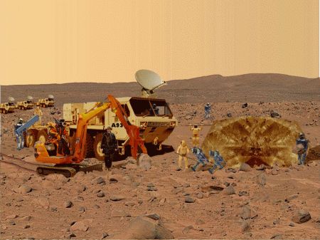
Robots set to work extracting the diamond from the martian soil in the Acidalia Planitia Mars.
Special report from the plain of Acidalia: Mars.

"The Star of Mars" on route to Hellas city: Mars.
Click image to enlarge.
What part of Mars are we looking at? This chart is in relationship with Hellas City, capital of Mars.
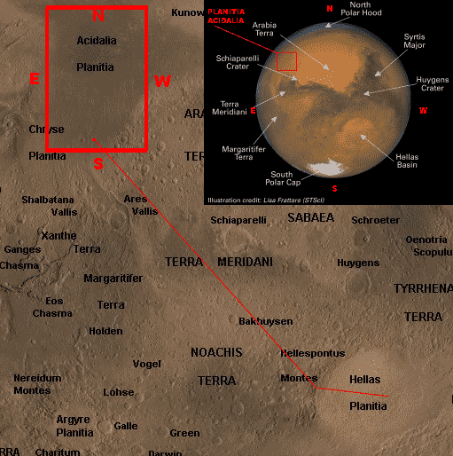
Were we are in relation to the Hellas crater.
Were did this mega diamond come from? The Acidalia plain is 6 kilometers below sea level and not the sort of place you would ever dream of searching for diamonds in. Why? Because diamonds are formed by prolonged exposure of carbon bearing materials to high pressure and temperature. Acidalia was a sea in the past and yes water is weight on the land "down pressure" yet at only 6 Km deep and one third the gravity of Earth you would not expected a titanic diamond to form at all, in fact I would not expect even little ones to form.
On Earth, the formation of diamonds is possible because there are regions deep within the Earth that are at a high enough pressure and temperature that the formation of diamonds is thermodynamically favorable. Under continental crust, diamonds form starting at depths of about 150 kilometers (90 miles), where pressure is roughly 5 gigapascals and the temperature is around 1200 degrees Celsius (2200 degrees Fahrenheit). Diamond formation under oceanic crust takes place at greater depths because of higher temperatures, which require higher pressure for diamond formation. Long periods of exposure to these high pressures and temperatures allow diamond crystals to grow larger.
Through studies of carbon isotope ratios (similar to the methodology used in carbon dating, except with the stable isotopes C-12 and C-13), it has been shown that the carbon found in diamonds comes from both inorganic and organic sources. Some diamonds, known as harzburgitic, are formed from inorganic carbon originally found deep in the Earth's mantle. In contrast, eclogitic diamonds contain organic carbon from organic detritus that has been pushed down from the surface of the Earth's crust through subduction (see plate tectonics) before transforming into diamond. These two different source carbons have measurably different 13C:12C ratios. Diamonds that have come to the Earth's surface are generally very old, ranging from under 1 billion to 3.3 billion years old.
Diamonds occur most often as euhedral or rounded octahedra and twinned octahedra known as macles or maccles. As diamond's crystal structure has a cubic arrangement of the atoms, they have many facets that belong to a cube, octahedron, rhombicosidodecahedron, tetrakis hexahedron or disdyakis dodecahedron. The crystals can have rounded off and unexpressive edges and can be elongated. Sometimes they are found grown together or form double "twinned" crystals grown together at the surfaces of the octahedron. This is all due to the conditions in which they form. Diamonds (especially those with rounded crystal faces) are commonly found coated in nyf, an opaque gum-like skin.
Diamonds can also form in other natural high-pressure, high-temperature events. Very small diamonds, known as microdiamonds or nanodiamonds, have been found in impact craters where meteors strike the Earth and create shock zones of high pressure and temperature where diamond formation can occur. Microdiamonds are now used as one indicator of ancient meteorite impact sites.
Surfacing
Diamond-bearing rock is brought close to the surface through deep-origin volcanic eruptions. The magma for such a volcano must originate at a depth where diamonds can be formed, 90 miles (150 km) deep or more (three times or more the depth of source magma for most volcanoes); this is a relatively rare occurrence. These typically small surface volcanic craters extend downward into formations known as volcanic pipes. The pipes contain material that was transported toward the surface by volcanic action, but was not ejected before the volcanic activity ceased. During eruption these pipes are open to the surface, resulting in open circulation; many xenoliths of surface rock and even wood and/or fossils are found in volcanic pipes. Diamond-bearing volcanic pipes are closely related to the oldest, coolest regions of continental crust (cratons). This is because cratons are very thick, and their lithospheric mantle extends to great enough depth that diamonds are stable. Not all pipes contain diamonds, and even fewer contain enough diamonds to make mining economically viable.
The magma in volcanic pipes is usually one of two characteristic types, which cool into igneous rock known as either kimberlite or lamproite. The magma itself does not contain diamond; instead, it acts as an elevator that carries deep-formed rocks (xenoliths), minerals (xenocrysts), and fluids upward. These rocks are characteristically rich in magnesium-bearing olivine, pyroxene, and amphibole minerals which are often altered to serpentine by heat and fluids during and after eruption. Certain indicator minerals typically occur within diamondiferous kimberlites and are used as mineralogic tracers by prospectors, who follow the indicator trail back to the volcanic pipe which may contain diamonds. These minerals are rich in chromium (Cr) or titanium (Ti), elements which impart bright colors to the minerals. The most common indicator minerals are chromian garnets (usually bright red Cr-pyrope, and occasionally green ugrandite-series garnets), eclogitic garnets, orange Ti-pyrope, red high-Cr spinels, dark chromite, bright green Cr-diopside, glassy green olivine, black picroilmenite, and magnetite. Kimberlite deposits are known as blue ground for the deeper serpentinized part of the deposits, or as yellow ground for the near surface smectite clay and carbonate weathered and oxidized portion.
Once diamonds have been transported to the surface by magma in a volcanic pipe, they may erode out and be distributed over a large area. A volcanic pipe containing diamonds is known as a primary source of diamonds. Secondary sources of diamonds include all areas where a significant number of diamonds, eroded out of their kimberlite or lamproite matrix, accumulate because of water or wind action. These include alluvial deposits and deposits along existing and ancient shorelines, where loose diamonds tend to accumulate because of their approximate size and density. Diamonds have also rarely been found in deposits left behind by glaciers (notably in Wisconsin and Indiana); however, in contrast to alluvial deposits, glacial deposits are not known to be of significant concentration and are therefore not viable commercial sources of diamond.
Diamonds can also be brought to the surface through certain processes which may occur when two continental plates collide and deeply formed rock is thrust to the surface, although this phenomenon is less understood and currently assumed to be uncommon.
I reckon the diamond came from Tharisis the volcanic region of Mars the land of Olympus Mons ;
Two possibilities if you look at the map below...The area were the diamond was found is in the flood plain of "directly" the Ares Vallis...Plus the Vallis Marineris. Given the criteria for diamond formation, the Vallis Marineris is the logical choice as route of passage being associated to Olympus Mons...What is Olympus Mons?
Olympus Mons (Latin, "Mount Olympus") is the tallest known mountain in our solar system, located on the planet Mars at approximately 18� N 113� W. Before space probes revealed its identity as a mountain, Olympus Mons was known to astronomers as the albedo feature, Nix Olympica ("Snows of Olympus").
The central edifice stands 25 kilometres (about 88,600 feet) high over its base (about three times the height of Mount Everest above sea level and 2.6 times the height of Mauna Kea above its base); it reaches 22 km (13 miles) above the mean surface level of Mars, since it stands in a 3 km (1.2 mile)-deep depression. It is 550 km (342 miles) in width, flanked by steep cliffs, and has a caldera that is 85 km (53 miles) long, 60 km (37 miles) wide, and up to 3 km (1.8 miles) deep with six overlapping pit craters. Its outer edge is defined by an escarpment up to 6 km (4 miles) tall unique among the shield volcanoes of Mars.
The size of Olympus Mons is so great (roughly the size of the American state of Arizona) that a person standing on the surface of Mars would be unable to view the profile of the volcano even from a distance as the curvature of the planet would obscure such detail. The only way to view the mountain properly is from orbit. Similarly, if one were to stand on the highest point of its summit, the slope of the volcano would extend all the way to the horizon.
Now thats sounds like a volcano capable of forming a 5 ton Diamond-O) So much lava has flowed out of Olympus Mons it has caused the mantle, the surface of Mars to buckle, and bend due to the sheer weight of the lava ejected; imagine a cannonball placed on a taunt out-streched linen sheet...Thats about the state of the area...Thats a lot of down pressure and given that diamonds are formed by prolonged exposure of carbon bearing materials to high pressure and temperature. The region of Olympus Mons "fits the bill".


Ares Vallis in the south of Acidalia Planitia: Mars. note: The colour blue is low ground.
Image credit: Google Mars.
You can see were the diamond was found...Also the Ares Vallis is a valley on Mars which appears to have been carved by fluids, perhaps water. The valley 'flows' out of the hilly Margaritifer Terra, passes through the ancient Xanthe Terra highlands, and ends in a delta-like region of Chryse Planitia in the south of the Planitia Acidalia region.
Impact at Hellas on Mars...

Watch the other side of the Planet Mars after impact.The impact object traverses the interior of the planet and impacts with the interior side of the planets crust. this is the Region of the Tharisis Bulge were the volcanos are.: Mars:
The Hellas crater on Mars was apparently created by a fragment of rock approximately the size of the largest asteroid,
Ceres, which is 578 miles (933 kilometers) in diameter.
The colossal fragment, is estimated to have hit Mars
a direct blow from the western quadrent of space,
at 25,000 mph (40,235 kph).
Which is 420 miles per minute (675 kpm),
7 miles per second (11 kps).
This impact would have created sudden, immense pressure waves
estimated to have traversed the interior of mars around 3,000 mph (4,828 kph).
Note:- Given the new definition of a planet by IAU's "planet definition committee" in Aug 06 and given the estimated figures of the impact object are correct it follows that the impact object that created the hellas crater was round unless it was a fragment of a larger body...QUOTE:
"Ceres by far the largest asteroid at 933 kilometres across, Ceres was called a planet when first discovered in 1801. But further findings of asteroids between the orbits of Mars and Jupiter led astronomers to class it with those smaller objects. A study last year of Hubble Space Telescope images proved that Ceres is round, placing it within the new definition."
AP. The Sydney morning Herald: August 16, 2006 - 12:34PM
Mars image credit: Hubble telescope.
Now of course it only my opinion however I reckon that little animation above is how to create a five ton diamond; QUOTE from a paragraph above "Very small diamonds, known as microdiamonds or nanodiamonds, have been found in impact craters where meteors strike the Earth and create shock zones of high pressure and temperature where diamond formation can occur.". Imagine the sort of pressure when that piece of rock the size of Texas USA hit Hellas on Mars.
Someone, or I read it somewhere, said that if I were travelling at 6O mph and if I impacted head on with a stationary object my impact weigh would be over a ton...If correct, then if I were travelling at 25,000 mph my impact weight would be 416.666 tons. So if the rock that hit Mars weighted a Sqillion tons it weighted 416.666 sqillion tons when it impacted.
(I am useing Squillions because I do not have a calculator that can handle the figures if you want an approx "correct answer" here are the maths.Good luck-O).. * 9.5�1020 kilograms to the power of 20 X 416.666 *)
To get an idea of its size, if all the material excavated from the Hellas impact crater were spread evenly on the continental United States, there would be a 3.5 km (2 miles) thick layer of debris.
Most asteroids (3 out of 4) are made of carbon-based rock. So we have the material and the means for creating "Giamonds" (Gigantic Diamonds)Creation of the Tharsis region ...Mars.

The Tharsis region on Mars is an enormous volcanic upland located on Mars' equator, at the western end of Valles Marineris.
It contains the Tharsis Bulge, on which some of the solar system's largest volcanos are located. Olympus Mons is at top left. At center, diagonally from top to bottom are Ascraeus Mons, Pavonis Mons and Arsia Mons (collectively known as Tharsis Montes). Tharsis Bulge rises up to 10 kilometers above its surroundings and covers 30 million square kilometers. It is thought to have been formed by a mantle plume over a period of about a hundred million years during the Noachian epoch.
The vast size of the Tharsis Bulge had a great impact on the geology of Mars. Tharsis is surrounded by a ring-shaped topographical depression called the Tharsis trough, and on the opposite side of the planet is a smaller bulge called Arabia Terra which may have formed as a result of the weight of Tharsis. These features were a major influence on the formation of Mars' drainage valleys, most of which formed in the late Noachian. The large quantities of carbon dioxide and water vapor that could have been outgassed by Tharsis magma may have also played a significant role in Mars' wet period; Roger J. Phillips calculated in 2001 that it could have formed a 1.5-bar carbon dioxide atmosphere and a global layer of water that averaged 120 meters thick.
This animated image "above" show the impact object "the rock" passing through the interior of Mars colliding with the area of Tharsis on the rebounding off the interior crust and hitting the Terre Arabia (image right) were a second martian bulge is located. The angle and ballistics of this theory appear to be well within the frame of possibilities.
Satillite image: Volcano peaks of the Tharsis region: ...Mars.

Clouds hover over the volcano peaks of the Tharsis region in this color mosaic image. Olympus Mons dominates at upper left. At center are the three Tharsis Montes: Arsia Mons at bottom, Pavonis Mons at center; and Ascraeus Mons at top. Image Courtesy NASA/JPL-Caltech
The Valles Marineris: Mars.

At 4,500 km long, 200 km wide and 11 km deep, the Valles Marineris rift system is ten times longer, seven times wider and seven times deeper than the Grand Canyon of Arizona, making it the largest known crevice in the solar system.
The Valles Marineris is located along the equator of Mars, on the east side of the Tharsis Bulge, and stretches for nearly a quarter of the planets circumference.
Mars image credit: Hubble telescope.
The Valles Marineris on Mars borders the Tharsis region and is probably a simple rip, tear, lession, as the impact object did not have sufficient force or mass to blast its self out of the other side of Mars it just bounced around inside making a real mess of Mars's magnetic field.
Valles Marineris opens into an area at it eastern end called the Labyrinthus Noctis and this is an area of "geo-chaos" same at the other end, just what you would expect from a tear in the crust.
Anyway I resume my trek northward, towards my objective "The Acidalia temple complex" on the Red planet.
Satillite image: The Acidalia Planitia temple complex; Mars (False colour).
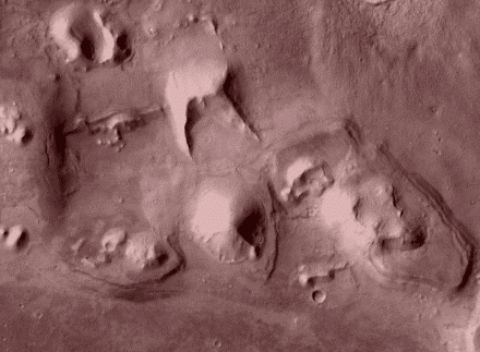
Objective: A group of features in Acidalia Planitia that may be constructions...?
Image credit: Themis-data ASU.
Coming soon "Journey to the Centre of Mars"
UPDATE:- Tunnel: Lake Xanadu to Hellas

Work has begun on the tunnel from the Hellas city to lake Xanadu, the 10,000 kilometers of tunnel will be constructed by Mars light and Power:
...So stay tuned...For more info from the Mars Chronicle, RHS1 News Service, Hellas, Mars.
Coming soon: Exclusive to the Mars Chronicle.

To learn more click the title above.
All the best...Indiana : September 2006 Mars
Your roving reporter for the Mars Chronicle
Optica
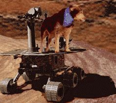
To boldly go were no dog has ever gone before!.

satellite image map of Mars .
..Click here
satellite image map of Mars . ..Click here

Purple Matrixx : Global Matrixx free software .
..Click here
Purple Matrixx : Global Matrixx free software . ..Click here
Back issues of the Mars Chronicle Edition 1:: Edition 2:: Edition 3:: Edition 4::
Contact Sally Your Webmistress
Your page manager...Indiana : Mars


Facts and figures for regions of Mars and diamonds: Courtesy of Wikipedia.
Reproduced under GPL license:Click here to view license::